Monday, March 31, 2008

Severe Threat Minimized For Tonight


It looks like a bust for severe weather across Indiana and Illinois. A few warnings were issued in Illinois but things never quite came together for a large scale severe weather threat. Even the areas of Texas, Oklahoma, Arkansas, Missouri, and Kansas that saw severe weather off and on all day never really saw a significant outbreak.

It does looks like some non-severe thunderstorms will pass through in the overnight and rain looks to hand around well past midnight but I doubt any warning will be issued unless they are flood related.

Tuesday will be cooler and Wednesday will be the best day with sunshine. Thursday and Friday being another possible severe weather threat and rain of course. I am sure the farmers are starting to get a little nervous about so much wet weather. I know I would be at this point.

The Sun Is Out!

For a brief while the sun is shining and may start to get a few things going. The temperature has jumped into the 60's and while I was a little off on my call of yesterday about the warm front tornado threat, the SPC is also showing come concern with a new MCD issued.


Compare with this map I drew yesterday. Remarkably similar.

Cloud Deck Prohibiting Storms

It looks like the widespread cloud deck across Illinois and Indiana is not allowing initiation of thunderstorms. There is severe weather in Kansas, Oklahoma, and Missouri.

No change to the slight risk areas but the moderate risk did creep somewhat north and east a bit.

We are at 57 currently so we may well get our 3rd 60 degree day of 2008.

Severe Weather Likely Tonight

The NWS has is very near the slight risk to start off the day. I suspect with the updated outlooks today that it might shift over us ever so slightly. Maybe not. The moderate risk is a little further south than I expected.


Our area should see the most severe weather in the late evening and overnight. It would be an excellent day to pick up a weather radio if you didn't have one since this looks to be a long duration event and I doubt anyone will be awake all night monitoring television or radio. The NWS as asked spotters to be available from 9 PM to 4 AM. (That will make for a long day.)

The composite radar page is now active. - http://kokomo-weather.com/radar.htm

You can see the large number of lightning strikes and when Oklahoma saw the severe weather remain active all night with warning after warning. Upper Iowa and lower Minnesota are receiving heavy snow at the rates of 1 to 2 inches per hour.

Sunday, March 30, 2008

Hook Echo Tonight

A classic hook echo on an after dark storm in Oklahoma tonight.

[Update #2] Severe Weather Forecast (Sunday - Tuesday)

Today started out a little rocky but died down before lunch. However I would not be the least bit surprised to see an evening of thunderstorms across Texas and Oklahoma. Monday looks rather ominous with a very large area of slight risk stretching into western Indiana. Missouri has the potential to be a moderate risk tomorrow.

A somewhat overlook area of concern is the northern Illinois area highlighted in pink below. Severe potential associated with warm fronts can be difficult to understand and reliably predict. However some notable severe weather outbreaks have been associated with a warm front including the 1965 Palm Sunday outbreak which devastated many places in Indiana.

For our area on Monday, expect some isolated thunderstorms ahead of the cold front. This activity will in the evening and after dark which seems to happen a lot in Indiana. Nothing is more fun than trying to spot severe weather in the dark.


[Update #1] Severe Weather Forecast (Sunday - Tuesday)

Last evening after I posted thing got fired up in Texas and Arkansas in the overnight. Mainly hail and some wind damage reports. Today already is busy with thunderstorm warnings Texas and Louisiana. You can see slight risk areas over the next 2 days do not include Indiana. We are under a general risk however and I would anticipate some thunderstorms today in fact.

Monday evening and overnight will be our best time for Thunderstorms and rain. There could be some lingering pockets of Thunderstorms remaining into Tuesday. The passing cold front might be a little slower than current forecast models are showing.

We also might be under the severe weather gun metaphorically speaking later in the week too.


Severe Weather Forecast (Sunday - Tuesday)

It looks to an active couple of days coming up starting with Sunday. Things will happen Sunday in the Texas Panhandle, across Oklahoma and into Kansas and possible a little more north and east. Monday will bring severe weather closer with parts of Missouri, Iowa, Wisconsin, and Illinois being in the thick of things. Kentucky and Indiana will also see some possible severe weather.

Things for our area will be in the evening into the overnight. At this point it doesn't look like a major outbreak for us but things can always change. Northern Illinois and northwest Indiana seem to be a better place for severe weather.

The good news is Monday should break 60 for only the third time this year and the rain over the next three days will remain at a reasonable amount of 1 inch or so.

More updates tomorrow as things begin to happen and as information for our area become more clear.

Friday, March 28, 2008

Severe Weather & 70 degrees

We have not reached 70 degrees yet in 2008! Also, I see any forecast thru next week showing temperatures even into the 60's for Kokomo. Our only days recorded above 60 were January 6th and 7th. Last year we had already seen an 80 degree day by now. This weather pattern is very depressing.

Today will remain cool but no precipitation should fall. Saturday looks to be sunny but still chilly. Sunday and Monday bring in a serious rain threat potential of several inches across an area of the county already saturated with rain and snow melt. Look for flooding conditions to remain for many people.

The rain threat also carries with it the potential for severe weather. We are at the top of the Day 4 risk area. That is mainly for Monday afternoon into the overnight hours. I will watch for additional information and should have a better idea on the specifics starting on Sunday afternoon one the updated Day 2 forecast is presented by the SPC.

Thursday, March 27, 2008

Zonal Jet Stream Divides Country

The jet stream has been in a zonal flow across the mid section of the country for several days now. The cold weather has been north with wamer temps south. It should move a little bit north the first of next week.


Snow North; Severe South, Rain Here

We are sandwiched between snow to the north and severe weather to the south. Expect some sleet and snow flurries overnight into tomorrow all mixing with a cold, cold rain. :(

Wet 24 Hours Ahead

Rain should be the flavor of the day (and overnight). Next week starts another rain train over the same areas which were hit last week. Models vary in amounts from 6 to 10 inches or more. The last time we all were convinced there was no possible way it could verify but it did. I guess this seems much more plauseable at this point given the recent history.

Wednesday, March 26, 2008

Today Was Spring

It was a beautiful day today. I was out around lunch time and if I didn't have a full schedule of meetings, I might have not returned to work.

Rain will be likely thru Thursday night and then some snow flurries are possible on Friday. Saturday should be another decent day with Sunday and Sunday evening turning to rain and thunderstorms.

Tuesday, March 25, 2008

Enjoy Wednesday, Rain & Storms Thursday

Wednesday looks to be about as decent of a day as we can expect with this less than stellar weather pattern. It will be the warmest day this week with temps in the lower 50's.

Thursday has us under a 5% chance for thunderstorms in the afternoon and evening. The set up looks pretty weak overall however. Next week (Sunday/Monday) looks better for a severe weather event.

Models Forecasts and DST

Just a note about the forecast models. When we sprung forward for DST a couple of weeks back, the models run times didn't change. The NAM which goes out to 84 hours now starts at 10 AM & PM and finished about 10:45 AM & PM. The GFS which is a longer range forecast tool which goes out 384 hours starts at 11 AM & PM and doesn't finish until 1:30 AM & PM. Both of those forecast models trigger additional forecast and analysis tools which finish even later.

That makes my late night forecast more difficult since I am very unlikely to stay up unless a major event is likely. My lunch time posts are also hindered by the later run times. Sorry...

Windy!

The wind is blowing from the south at a brisk pace. While it is bring some warmer surface air, it is not helping the cold air aloft. The wind chill also is not making it feel very comfortable either. This might be the best day of the week. Tomorrow will be the other potentially good weather day.

The thunderstorm potential for later in the week seems to have dissipated. Now just expect some rain before a warm up over the weekend.

Monday, March 24, 2008

Spring Delayed

We are not warming up with the spring season. While the surface can heat up during the daytime sun there remains a large pocket of cold air over much of region which is keeping us with below normal temperatures. The longer forecast products shows continued cold and while I don't see a significant snow for our area, the (snow) rich with keep getting (snow) richer. Place like Rockford, IL and Madison, WI and across souther MI will likely see a couple more good snows.

The early forecasts showed the week warming up to near 60 locally by Friday but now the forecasters have dropped things back down to low 40's for Friday. There does appear to be a tight temperature gradient acorss Indiana starting on Thursday into the weekend. While we could see 40's, south of I-70 will see 60's. This tight gradient has some limited potential to make a few isolated thunderstorms acorss the region Thursday evening into Friday.

In general I would say the weather pattern for the next week will be crummy. Rain, cooler temps, some possible thunderstorms and end of the week snow flurries. Nothing spring like about this weather pattern.


Tuesday looks like the only sunny day but it will be windy so even a seasonal temperature will seem cold. :(

Sunday, March 23, 2008

Warmer Week Ahead

The week looks to be warming up and be wet with rain several days/nights too. Thursday, Thursday Night, and Friday look to have thunderstorms along with the rain. The current parameters do not appear to support a large scale severe outbreak for our area at this current time. Some isolated severe storms are still possible however.

The snow storm for next weekend I first mentioned on Wednesday still looks like someone will get snow on the backside of the Thursday and Friday storms. It should be noted Madison, Wisconsin topped 100 inches of snow this season. The old record was 76.1 inches from the great winter of 78-79.

Friday, March 21, 2008

Too Late For Severe Weather

Some isolated cells are finally firing up across north of I-70 but it is too late for them to gorw into anything other than a small hail producer. There have been a few scattered reports of hail to the NWS. There is a chance for snow flurries tonight and tomorrow but no accumulations other than a dusting. It will be cooler the next couple of days.

Good Friday Forecast

The big snow shifted but went north rather in our direction. Those in lower Wisconsin are going to get buried. Madison has a real shot of breaking a 100" snowfall which would be a record that should stand for an awfully long time.

Our forecast is for rain and thunderstorms. Some very weak instability is across Illinois, Indiana, and Ohio. A high in the low 50's for today with rain overnight. Some mixing with snow is possible but accumulations will be light if at all. Cooler tomorrow with a high in the 30's.

Just consider the next couple of days to be dreary...

Thursday, March 20, 2008

Good Morning before Good Friday

Good morning abet a little chilly. It will warm up into the 50's today. Everyone is talking snow to our north with Winter Storm Watches posted by the NWS. One key to the Friday clipper is the snow path is narrow and will drop 4 to 8 inches. As we have seen all winter, the forecast track and the actual track can differ quite often.

Currently the winter storm track includes Plymouth and Warsaw. This is just 60 miles to our north. It wouldn't take much deviation south for us to see some of the snow from the system. I would not anticipate the heaviest snows but a couple of inches on Friday would not surprise. If it doesn't snow or even if it does on Friday, it will mix with rain.

I am glad to see the Sunday snow potential evaporate but it will be cooler in the 40's so the Easter Bunny might want to do his hiding of chocolate inside. (Note: Hollow chocolate bunnies are wrong; get the solid chocolate ones.)

Our snow for the last weekend in March is still hanging about. It is a widespread event unlike a narrow path from a clipper so small changes in the track still keep us under the threat of snow.

Wednesday, March 19, 2008

Friday Snow (Northern Indiana)

A Winter Storm Watch was issued by the northern Indiana NWS office. It does look like we will not see any accumulations from this system unless it take a dive to the south by 50 to 75 miles.

...LATE SEASON WINTER STORM LIKELY FRIDAY INTO SATURDAY....

A LATE SEASON WINTER STORM SYSTEM WILL HAVE THE POTENTIAL
TO PRODUCE SIGNIFICANT SNOWFALL AMOUNTS FRIDAY INTO
SATURDAY AFTERNOON ACROSS MUCH OF NORTHERN INDIANA...
SOUTHWEST LOWER MICHIGAN...AND NORTHWEST OHIO. SNOWFALL
ACCUMULATIONS OF 4 TO 8 INCHES WILL BE POSSIBLE BEFORE
TAPERING OFF SATURDAY AFTERNOON.

...WINTER STORM WATCH IN EFFECT FROM FRIDAY MORNING
THROUGH SATURDAY AFTERNOON...

THE NATIONAL WEATHER SERVICE IN NORTHERN INDIANA HAS ISSUED
A WINTER STORM WATCH...WHICH IS IN EFFECT FROM FRIDAY
MORNING THROUGH SATURDAY AFTERNOON.

A WINTER STORM SYSTEM WILL DEVELOP ACROSS THE PLAINS
THURSDAY NIGHT AND MOVE EAST INTO THE REGION FRIDAY
MORNING. THIS POTENT SYSTEM WILL PULL AMPLE AMOUNTS OF
MOISTURE FROM THE GULF OF MEXICO AS IT MOVES THROUGH THE
REGION FRIDAY INTO SATURDAY. THE HEAVIEST SNOWFALL LOOKS
TO OCCUR FRIDAY EVENING INTO FRIDAY NIGHT. ALLOWING FOR
SIGNIFICANT ACCUMULATIONS OF 4 TO 8 INCHES THROUGH SATURDAY
AFTERNOON. A SMALL AMOUNT OF UNCERTAINTY STILL EXISTS WITH
WITH EXACT TRACK OF THE SYSTEM...PERSONS IN AND NEAR THE
WATCH AREASHOULD WATCH FOR UPDATES ON THIS POTENTIAL
WINTER STORM.

A WINTER STORM WATCH MEANS THERE IS A POTENTIAL FOR
SIGNIFICANT SNOW...SLEET...OR ICE ACCUMULATIONS THAT MAY
IMPACT TRAVEL.

Let's Talk Winter (Snow)...

While the topic of rain has been on everybody's mind the past few days and everybody, including me, is ready for spring, winter is still holding and want to provide us with more opportunities for snow. (I guess it didn't get the memo that Spring starts tomorrow.)

Today will be some possibility of back side snow with little to no accumulation. Friday will be a clipper shooting down Canada and it looks to be the one to drive Madison, WI over 100 inches of snow for the first time every in a season. It will dive across Chicago, along the Michiana border and then over and up through Cleveland and Buffalo. Doubtful will we see much snow from this event but some possible flurries could mix in Friday evening into Saturday maybe leaving an inch behind. Should the clipper move southeast in it's track then the heavier bands of 4 to 6 inches could be possible.

The Easter Sunday snow maker did fizzle out for our area. The middle Atlantic states are is heaven right now with talk of a huge Easter Sunday into Monday snow for them. The HPC put out this weather treat for them...

THIS GUIDANCE THREATENS A FOOT OF SNOW FROM NEAR
RICHMOND NORTHEASTWARD TO BOSTON...INCLUDING WASHINGTON
DC...PHILADELPHIA...AND NEW YORK CITY.

If that would verify, they would finally see a good snow maker this season. Places like Washington DC have been snow starved this season. I hope my online weather friend that lives in Washington DC gets her snow. She is a Howard County transplant and really would like to see some snow.

So what about us? The weather pattern seems to keep flopping back and forth between snow and severe weather for the next 15 days. Our biggest snow coming up looks to be on or near the last weekend of the month. This low track north of us which isn't our best set up but the precipitation amounts along with a negative tilt to the jet overhead with a combined closed low should make for a good 6 to 8 inch dumping of snow. There will be lot of weather in the next 10 days or so and lots of things could change so all we can do is watch and see if winter has one more snow in store for us. Maybe the snow hype machine can be fired up one last time.


Rain and then snow today...

We have an inch of rain with another 1/4 to 1/2 inch possible today. Snow should come in late afternoon on the backside and make a dusting. In the same time frame we have had our inch if rain, Cape Girardeau, Missouri has has 12 inches and it is still falling.


Tuesday, March 18, 2008

More Rain Overnight and Wednesday

We are at 1/2 inch currently and I would anticitpate another 1/2 to 1 inch before all is said and done tomorrow. Our area has gotten off extremely lucky compared to southern IL and southeastern MO where reports of 6 to 10 inches have been reported. Some areas will likely top 15 inches in a 48 hour window causing historic and record flooding.


We are nowhere near flood stage in Kokomo.

Good News

There is good news for our area. it looks like the heavier rain is staying south of I-70. Out total accumulations should be around 1 to 2 inches. The rain is very heavy south and there are many reports of 2 to 4 inches already with another 2 to 4 inches forecast for today and tonight. There is a small chance of some back end snow tomorrow late into the evening but accumulations look light.

Monday, March 17, 2008

Prepare to get wet...

Have I mentioned it might rain sometime soon? *grin* No changes to the models. They all keep showing significant rain totals. I do think we warmed up to miss the sleet and snow.

Overnight Snow & Sleet Possible

It looks like the temperature is falling a little more than originally forecast. Expect some periods of snow and sleet with no accumulations. Snow and sleet has been reported in IL and parts of Indiana.

Heavy rain is still likely over the next 48 hours. Three inches or more possible with isolated pockets of 4 inches or more.

Rain & Maybe Some Snow...

The rain should be over our area by this evening. Signs still point to a significant amount of rain topping 2 to 3 inches. Some localized rainfall could top 4 inches. I would be remiss if I didn't mention some forecasters mentioning snow on the back end of this system on Wednesday afternoon and evening. I have heard amount of as much as 6 inches. I think there might be some mixing on the end but no accumulations seem likely right now. A possible dusting of snow on Friday is also in some forecasts. Now the Easter snow on Sunday looks more likely.

General Risk For Thunderstorms

We have a general or very slight risk for thunderstorms today and tomorrow. We also have a flood watch in effect and the National Weather Service is acknowledging a possible 3 to 4 inches of rain in the next 48 hours.


Sunday, March 16, 2008

Heavy Rain Likely

The forecast models are coming into agreement and keep showing the significant rain for Monday through Wednesday. I think a minimum of 1.5 to 2 inches with possible higher amounts nearing 4 inches or maybe more. The bulk of the rain will be Tuesday afternoon into Wednesday morning. There will be a train of thunderstorms moving along the front which will bring periods if very heavy rain. The thunderstorms are not expected to be severe at this time.


WATCH OUT FOR THE RAIN!

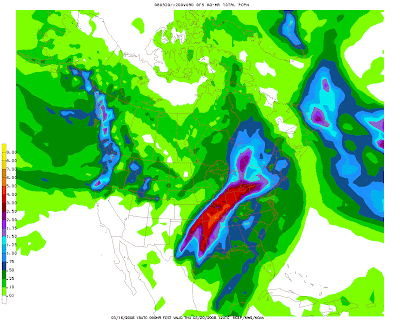
The models keep showing a significant amount of rain. This is the last three runs of the GFS and all three runs show a monsoon. All maps depict the previous 60 hours of rain ending on 7 AM Thursday.


And to add some insult to injury, it looks like an Easter snow is possible. The map below depicts a good 6-8 inch snow storm for our area.

Saturday, March 15, 2008

Heads Up For Rain...

It looks like the start of next week will be very rainy. Forecast models are showing widespread showers with amounts from Monday thru Wednesday totaling 4 to 6 inches. It likely will be more in the 2 to 3 inch range with isolated heavier amounts possible. I guess we will need to break out the boats.

Friday, March 14, 2008

The weekend forecast...

It was a wonderful day yesterday and should be nearly as good today but without the sunshine. That will make it cooler of course. Saturday looks to be a rain, dreary day with some back end snow potential but no accumulations. Sunday will be the best day of the weekend with warmer temperatures and sunny skies.

Nothing else to mention other than rain and some severe weather are likely to start next week.

Wednesday, March 12, 2008

Weekend Snow

It does look like the potential for snow is still hanging around for Saturday. No significant accumulations but 1-3" still could fall making for a mess evening and overnight. Temperatures are marginal but do show snow so...

Next week looks like a potential stormy start with severe weather across much of the central US including our area. The weekend severe weather should remain south on Friday and Saturday.

General Risk for Thunderstorms

The Storm Prediction Center had the northern half of Indiana under a general risk for thunderstorms. Very low risk potential and we don't even have rain in our forecast for today. Hopefully we will reach our projected high of 50 today. I would enjoy seeing some warmer weather.

Tuesday, March 11, 2008

Warm Weather Ahead

Some warmer and sunny days are ahead for Tuesday and Wednesday. The upcoming snow potential looks to be a minimal threat with marginal temperatures. Expect rain with some mixing so maybe an inch but likely less.

The warming is causing a snow melt and once the snow pack is gone the ground will also begin to thaw. There is a lot of water in the snow and frozen tundra and when it makes its way to the streams and rivers you can expect more flooding conditions.

Overall the forecast models show a couple of systems moving through each week for the next 2 1/2 weeks. Some are marginal temperature snow makers and other looks to be typical spring storms. I suspect an active spring of weather given our recent history.

Monday, March 10, 2008

Another Weekend Snow Storm?

The week will warm up bring a meltdown to any remaining snow. Thursday into Friday look like possible rain at this time with a switch over to Snow for Saturday. The weekend snow has been pretty consistent on the models. It will be something to watch for later in the week.


Sunday, March 9, 2008

Warmer week ahead...

The snow forecast for the upcoming week looks bleak. Warmer weather will be on tap for the week. Unless there is some apocolyptic weather phenomenon, no way I make my three remaining snow days for area schools by weeks end. I did previously declare March 15 (Saturday) my cut off date. That isn't to say we are completely done with the snow but chances for big March snows are few and far between.

Ohio Blizzard 2008 as some care calling it did pack a powerful punch. You can find lots of news reports about the fun digging out and plenty of amateur videos online. I looked at several and liked this one. I can still dream how sweet it would have been to share in this one. (FYI: the distance between Columbus, OH and Kokomo, IN is just 169 miles. What a small shfit of the low could have brought.)

Video Credit: Kyle Ezell

Saturday, March 8, 2008

Our Advisory Cancelled

Our advisory for blowing snow is cancelled. All looks fine for us from this event. Have a great weekend and Go Tigers! I am off to Regionals!

The Storm Continues To (Snow) Bomb...

The storm continues to drop significant snow to our south and east. As the trough changes from its current positive tilt to a negative tilt over the next 24 hours, it will slow down and continue to draw moisture up from the gulf producing snow over TN, KY, OH, and southeast IN. Some people are making out like snow bandits with this storm. NWS offices in the warning and blizzard areas have been upping totals with the evening forecast. It sure would have been nice to have a piece of this one.

Friday, March 7, 2008

No Snow Yet

Nothing yet for us and most likely will see a just a trace to maybe an inch. The air outside is pretty dry with 63% humidity. They dew point needs to catch up to the temps so some of the virga will actually hit the ground as snow.

If you have not caught the news, there has been a fair amount of snow to our south and east. Blizzard Warnings cover much of Ohio. It will be a long weekend digging out for many.

FLAKE-FREE

We are flake-free in Kokomo. Things are really cranking to the south and east. Schools are dismissing. The snow is falling around an inch per hour. I am sure if you watch the (national) news channels or evening network newscast you will see some great snow stories. This is a large area impact storm but not here.

For us, expect a dusting to an inch by noon tomorrow. Gusty winds will also prevail.

For those wondering, The Plymouth 3A Regionals featuring the Northwestern Tigers looks ok to play. Some of the south regionals could be postponed.

SNOW AND BLOWING SNOW ADVISORY

The NWS has downgraded us to a Snow and Blowing Snow Advisory. This is in effect from noon Friday to 4 PM on Saturday. There has been a consensus that a southeast trend is real and we will only see a couple of inches from the storm.

Winds will be strong and gusty for the next couple of days causing blowing snow and reduced visibility.

Ohio will be the big winner for snow with a wide path from Cincinnati to Cleveland seeing 8 to 12+ inches of snow and lots of wind.

Spotter Training for Severe Weather

I have been lacking in my mention about the upcoming Spotter Training class held Saturday in Kokomo. it is at 1 PM at
County Office Annex, 120 E. Mulberry St. Even if you don't plan on heading out to spot, it is an interesting and informative 2 hour class.

Thursday, March 6, 2008

Quick Update

Not really any changes to the forecast overall for our area. There has been a small trend with the models to go southeast with the heaviest snow. With a tight gradient between snow accumulations, a 50 to 75 mile charge to the southeast would likely give us just a dusting. Tomorrow will be a lot of nowcasting to see where the storm actually tracks.

Hello Campers - Snow is Coming!

I am alive but this cold, the second one I have had in a month knocked me down all but good. It has been a struggle to do anything including look at this fabulous storm getting ready to hit Indiana and a large portion of the eastern US. Since I remain somewhat weak, I will offer a short synopsis of the storm. (Note: My prescription warns to not operate heavy machinery while taking the medication. It should also include a warning to not try and read long technical NWS discussions about the weather. *grin*)

The system will not be delivering it full punch to out area but will slide across southeastern Indiana and through Ohio. Those areas could see 8 to 12 inches of snow. We will be on the edge of the track and accumulations here would likely fall in the 3-6 inch range. This will a longer duration event lasting 24 to 36 hours. Wind will be a factor for the duration of the snow causing blowing and drifting.

Mu suggestion is to get a weekend of groceries and rent some good movies and enjoy the snow.

[NWS] WINTER STORM WATCH


..WINTER STORM WATCH IN EFFECT FROM FRIDAY MORNING THROUGH SATURDAY EVENING...

THE NATIONAL WEATHER SERVICE IN INDIANAPOLIS HAS ISSUED A WINTER STORM WATCH...WHICH IS IN EFFECT FROM FRIDAY MORNING THROUGH SATURDAY EVENING.

A STORM SYSTEM IS EXPECTED TO MOVE INTO THE AREA ON FRIDAY...AND LINGER INTO SATURDAY. THE POTENTIAL EXISTS FOR TOTAL SNOWFALL ACCUMULATIONS TO REACH OR EXCEED 6 INCHES BY SATURDAY EVENING. WIND GUSTS TO 35 MPH MAY DEVELOP BY LATE FRIDAY AFTERNOON AND CONTINUE INTO FRIDAY NIGHT AND SATURDAY...WHICH MAY RESULT IN CONSIDERABLE BLOWING AND DRIFTING SNOW.

A WINTER STORM WATCH MEANS THERE IS A POTENTIAL FOR SIGNIFICANT SNOW...SLEET...OR ICE ACCUMULATIONS THAT MAY IMPACT TRAVEL. CONTINUE TO MONITOR THE LATEST FORECASTS.

Tuesday, March 4, 2008

[NWS] Winter Storm Warning

The NWS in Indianapolis has upgraded us to a Winter Storm Warning (again). Around 3-5 inches of snow and more freezing rain up to 1/2 inch is possible.

Road Conditions Deteriorate

Road conditions are deteriorating. The scanner is busy with accidents on all roads and highways. I see on TV that many evening activities are cancelling. Power lines have also been reported down in several locations in Tipton County.

Snow Remains Likely

I first want to apologize for the short, sporadic updates. I have a terrible chest cold and have been sleeping mostly nonstop for the past 18 hours. Back to the weather...

It looks like we won't be teetering with the freeze line and the threat for freezing rain or ice is gone. Some sleet in accumulations of 1 inch or less remains possible. This evening will bring in some additional chances for snow with 1 to 3 inches. Nothing significant. The system should be gone from the area by tomorrow morning.

There are some other areas in east central Indiana reporting power outages. You can see map of Duke Energy customers without power here.

Sliding Southeast

The precipitation slide southeast and we didn't see problems as expected. The NWS has downgraded us to a Winter Weather Advisory for some sleet and snow. Accumulations are not expected to be heavy.

Monday, March 3, 2008

10:30 Update

Nothing new to report on the forecast side. It will be a long tense night for forecasters. Some sleet and freezing rain reported around the area. I suggest an early check of the weather and road conditions if you are venturing out in the morning.

Ice, Ice Baby...

Indianapolis has indicated the frozen temperatures have arrives several hours sooner than forecast. Slight glazing on grass and cars reported from Lafayette at 8:30.

[NWS] Winter Storm Warning

...WINTER STORM WARNING IN EFFECT FROM MIDNIGHT TONIGHT TO 4 PM EST TUESDAY...

RAIN CHANGING TO FREEZING RAIN BY MIDNIGHT. THEN FREEZING RAIN AND SLEET WILL OCCUR LATE TONIGHT THROUGH EARLY TUESDAY AFTERNOON. ONE QUARTER TO ONE THIRD OF AN INCH ICE ACCUMULATION IS EXPECTED.

A WINTER STORM WARNING MEANS SIGNIFICANT AMOUNTS OF SNOW... SLEET...AND ICE ARE EXPECTED OR OCCURRING. STRONG WINDS ARE ALSO POSSIBLE. THIS WILL MAKE TRAVEL VERY HAZARDOUS OR IMPOSSIBLE.

Cold Front Arriving...

The cold front is moving into the area bring steep temperature drops. Lafayette was at 60 around 7 AM and is now at 43. It will be interesting to see if any changes are made to the watch by the NWS. Much of central IL is reporting mid thirties and still falling.

No Forecast Changes...

The forecast seems to remain the same. Rain, freezing rain, sleet, & snow is all in the forecast over the next 36-48 hours. Freezing rain looks to be the biggest concern on the models but the NWS thinks 1/4 inch will be the maximum amount. I think tomorrow morning will be a real mess for travel. No guess on a snow delay or snow day for area schools. I would anticipate 2-3 inches by end of the day on Wednesday.

Winter Storm Watch

Not really any changes to the forecasts currently. The system might be a tad slower than the models have suggested. Hopefully some additional information by lunch but this may be more of a nowcast type of event.

...WINTER STORM WATCH IN EFFECT FROM THIS EVENING THROUGH TUESDAY AFTERNOON...

THE NATIONAL WEATHER SERVICE IN INDIANAPOLIS HAS ISSUED A WINTER STORM WATCH...WHICH IS IN EFFECT FROM THIS EVENING THROUGH TUESDAY AFTERNOON.

RAIN MAY CHANGE TO FREEZING RAIN TONIGHT. ICE ACCUMULATIONS AROUND ONE QUARTER INCH WILL BE POSSIBLE BY EARLY TUESDAY. AIR TEMPERATURES SHOULD RISE TO ABOVE FREEZING BY MIDDAY TUESDAY ENDING THE POTENTIAL FOR ANY ADDITIONAL ICE ACCUMULATIONS.

A WINTER STORM WATCH MEANS THERE IS A POTENTIAL FOR SIGNIFICANT SNOW...SLEET...OR ICE ACCUMULATIONS THAT MAY IMPACT TRAVEL. CONTINUE TO MONITOR THE LATEST FORECASTS.

Sunday, March 2, 2008

Late Evening Update

There hasn't been much change from any of the NWS forecast offices around the region since the middle of the afternoon. The last few runs of the forecast models have most of the snow band to our west and recently the frozen precipitation looks to be mainly south.

While south, it is just a couple of counties. The band is from Terre Haute to Carmel to Munice. We seen a modest amount of rain with a little over an inch. Modest is relative to this system. A small amount if sleet or ice is also likely but it doesn't look to be significant or devastating for us right now.

There is still a lit of uncertianty with the system and small changes of just a few miles could have significant changes in the forecast. This storm system will be more nowcast than forecast. The NWS office in Chicago said it this way...

ANYONE NOT FREQUENTLY MONITORING LATER FORECASTS MAY BE CAUGHT OFF GUARD.

I am attaching the precipitation map for the next 60 hours and the frozen rain and sleet maps too.


Late Afternoon Update

Here is one messy update. Let's begin with the HPC winter composite. The Day 2 Map begins at 7 PM Monday evening and shows us with a 10% chance for 4 or more inches of snow as well as 1/4 inch of ice being a 40% chance.

Most of the NWS forecast offices in the region have differing ideas on a storm system which still has the models stymied. It also has the forecasters mentioning a lot of uncertainty with their forecasts. Some are being aggressive and issuing winter watches and advisories and some are remaining conservative. At this point I don't fault either camp and can see the reasoning for their decisions.

Here is a run down what local NWS offices have issued and are thinking.

Indianapolis has issued a Flood Watch for all counties in their coverage area.

...FLOOD WATCH IN EFFECT FROM MONDAY AFTERNOON THROUGH TUESDAY
AFTERNOON...

* FROM MONDAY AFTERNOON THROUGH TUESDAY AFTERNOON

* RAINFALL TOTALS OF UP TO 2 INCHES ARE POSSIBLE WITHIN THE WATCH AREA.

* RAINFALL IN ADDITION TO SNOWMELT FROM NORTHERN INDIANA WILL CAUSE RISES IN AREA RIVERS. EXCESSIVE RAINFALL IN OTHER AREAS MAY RESULT IN FLOODING OF LOW LYING AREAS AS WELL AS STREETS...STREAMS AND CREEKS.

A FLOOD WATCH MEANS THERE IS A POTENTIAL FOR FLOODING BASED ON CURRENT FORECASTS.

The Northern Indiana NWS Office has went and issued a Winter Storm Watch for many counties in their coverage area including Miami and Grant. Cass is NOT included however.

...WINTER STORM WATCH IN EFFECT FROM LATE MONDAY NIGHT THROUGH WEDNESDAY MORNING...

THE NATIONAL WEATHER SERVICE IN NORTHERN INDIANA HAS ISSUED A WINTER STORM WATCH...WHICH IS IN FFECT FROM LATE MONDAY NIGHT THROUGH WEDNESDAY MORNING.

SIGNIFICANT AMOUNTS OF FREEZING RAIN AND SLEET WILL BE POSSIBLE LATE MONDAY NIGHT INTO TUESDAY EVENING AS A STRONG WINTER STORM MOVES THROUGH THE REGION. THERE IS STILL SOME UNCERTAINTY WITH THE EXACT TRACK OF THE SYSTEM WHICH COULD PRODUCE SHIFTS IN PRECIPITATION TYPE AND AMOUNTS...BUT ENOUGH EVIDENCE SUGGESTS THAT THE POTENTIAL THREAT FOR MODERATE TO HEAVY ICING EXISTS. CURRENT FORECASTS SHOW AMOUNTS OF ICING TO BE MAXIMIZED AT OR ABOVE ONE QUARTER OF AN INCH SOUTH AND EAST OF A LINE FROM WAUSEON OHIO TO FORT WAYNE TO PERU INDIANA. PRECIPITATION WILL BECOME ALL SNOW TUESDAY EVENING AND MAY ACCUMULATED AN INCH OR TWO INCREASING THE DIFFICULTY TO TRAVEL.

They also have a Flood Watch in effect for almost all of their coverage are.

Here are some key comments directly from the Indianapolis NWS discussion issued at 4 PM.

THINGS GET TRICKY ON MONDAY NIGHT. THERE IS A POSSIBILITY OF AN EXTEDNED FREEZING RAIN EVENT ALONG AND EITHER SIDE OF A LINE FROM MUNCIE...ANDERSON TO CARMEL.

WITH HIGH UNCERTAINTY REMAINING...HAVE OPTED TO HOLD OFF ON A WINTER STORM WATCH FOR NOW.

As you can see, they are being conservative with issuing a watch or advisory. All I can say is to pay attention as this system could bring a little bit of everything and decided at the last second where.

Storm Update

Here are the HPC Composites for this morning. The first one is valid from 7 AM Monday and the second kicks in at 7 AM Tuesday. You can see snow seems possible and ice seems very real too. Tuesday looks even more ominous with snow and ice. Ice has been mentioned by the NWS (Indianapolis) in their HWO.


The latest NAM model run shows significant frozen precipitation for our area. One inch or more is forecast. Models have been showing this solution more and more often with the heavier snow to the south east.


Saturday, March 1, 2008

Prepare For The Worst...

The next system looks impossible to forecast with any certainty. The models are flip-flopping on each run with the exact location of the freeze line. Here is what I can say at this point...

Someone is going to get hammered with snow. There is a very narrow band (maybe 50-75 miles) that will come up from the southern plains states through Eastern Iowa, Illinois, or Western Indiana. Amount would be 8 to 12 inches or more.

Someone is going to get flooded with rain. There is wide precipitation area which has generally put 2 to 4 inches over several states including ours. If we don't get the snow mentioned above, rain is very possible unless...

Someone could get a major ice storm with 1/2 inch to 1 inch or more. That would be devastating to trees and power lines. Again, it is really impossible to predict at this point since everything is so marginal on temperatures.

What should be hope for? I say snow. Why you ask? Snow won't take down trees or power lines. Snow won't bring an immediate flood situation. It would likely be a more gradual flood as it melts.

I will try to deliver at least a couple of posts on this system tomorrow and will also kick off severe weather awareness week with a recap of the NWS conference I attended today. That was a great time.

Angela Buchman Loves Kokomo-Weather.com