Sleet has been reported heavy at times across Howard County. Here is the QPF for this upcoming storm. This is going to make a lot of snow, sleet, and ice.

Sleet has been reported heavy at times across Howard County. Here is the QPF for this upcoming storm. This is going to make a lot of snow, sleet, and ice.

...Winter Storm Warning in effect from 7 PM this evening
to 7 PM EST Wednesday...
The National Weather Service in Indianapolis has issued a
Winter Storm Warning for heavy snow...sleet and freezing
rain...which is in effect from 7 PM this evening to 7 PM
EST Wednesday. The Winter Storm Watch is no longer in
effect.
* Main impact: roads will likely become impassable due to
heavy snow or icing...blowing snow will reduce visibility
...travelwill become very hazardous or potentially impossible.
Ice accumulations may result in widespread...long duration
power outages.
* Accumulations: snow accumulation in excess of 12 to 16
inches is possible in northwest central Indiana. Ice
accumulations in excess of one inch are possible along and
near the Interstate 70 corridor.
* Timing: precipitation is expected to begin Monday
evening and continue through Wednesday afternoon.
* Other impacts: wind gusts of 35 to 40 mph on Tuesday
and Wednesday in combination with heavy ice accumulations
will likely result in downed trees and power lines.
Precautionary/preparedness actions...
A Winter Storm Warning means significant amounts of
snow...sleet...and ice are expected or occurring. Strong
winds are also possible. This will make travel very hazardous
or impossible.

All quiet this morning but that will change by this time tomorrow and by Wednesday I am sure everyone will be saying uncle. Things continue to look like Kokomo will just miss the ice with this storm. (I hope nobody is planning an Indy trip this week.)
Snow amounts look to be 10-12+ inches when this is all said and done. I would not be surprise to see some amounts topping 15 inches.
Here is a high resolution snow map just produced.

They have came in stronger with more snow including in the first wave. There could be some significant changes to the forecast by tomorrow morning depending on what the Euro model does overnight.
Much less sleet and no ice with the solutions I have seen so far.
I wished this was an easy one but it isn't. Here goes...
6-10 inches of snow
1-2 inches of sleet
some icing but nothing significant for us
High winds causing drifitng
much colder end of the week
I do reserve to update this forecast as often as necessary.
One thing I will mention. If you are in the market for a battery operated light, the Rayovac Sportsman Extreme is excellent. They have these at Lowes and Meijer in town. Probably other places too.
This storm is all but impossible to forecast for our area. As expected, the models did a little dance this morning shifting this northwest. Not a lot but we have trended out of the record historical snows amounts. Those looks to be for Chicago. (Their all time record of 23" will probably fall.)
For Kokomo and Howard County, we are riding the line of mixed wintry precipitation. Making a call as to which one wins out is not possible right now. There is a lot of speculation and even the NWS is sending a mix message right now if you compare the forecast for Bunker Hill from the Northern Indiana Office and Kokomo forecast from Indianapolis.
This will probably be a nowcast where we really won't know until it is almost here or happening. I think if anyone makes a final call now, they are foolish. I also think it is not a good idea to think this thing has trended northwest and will now be a miss for central Indiana.
Options range from modest snow accumulations (4-6 inches) with sleet on the order of a couple inches or more. The snowiest solutions still come in the 14-16 inch range and no mixing issues. Icing doesn't seem like a serious threat for here right now but some minor amounts of a quarter of an inch is possible.
A few extremely key points are this will be a system in two waves. The first way will be Monday evening into Tuesday morning. You might look around Tuesday morning and think we busted. That will be a lull because by Tuesday evening, the heaviest amount of precipitation will be falling in one form or another. If snow, one to two inches per hour into Wednesday morning. Sleet or ice would be equally as aggressive with their accumulations and impacts. I would guess snow plows will park Tuesday evening when they see no hope of keeping up.
Winds will also be a significant factor. Snow will be blowing and drifting into Thursday. Colder temperatures will follow with lows near zero and highs in the teens for Thursday and Friday. If only small amounts of ice or sleet accumulates, the winds could cause power outages.
Here is the outage make for Duke Energy for Indiana - http://www.duke-energy.com/indiana/outages/current.asp#outagemap
Please do prepare to be home bound through the end of the week. Make sure you have medicine, non perishable food (and a non electric can opener) and water. A bathtub of water might be handy for those with a well and no electricity. You can use it to flush. :)
Batteries for a flash light and radio and keep your cell phones on charge.
I will update later this evening but I think this video I recorded of the Indianapolis NWS on The Weather Channel says it all. (This was from this morning.)
By now you know the National Weather Service has issued a Winter Storm Watch for Central and Northern Indiana. NWS has an excessive of 10 plus inches by Wednesday evening for our area. The good news is the ice threat seems to be staying south for now. It could be as close as southern Tipton County and turn into a full blown disaster by Indy metro.
This morning will be the first model runs will the storm fully on shore and sampled. Should there be any corrections in the storm track overall, it should happen with the 12z model runs. Check back later for your full forecast.
I don't have much to say that isn't in the earlier forecast around noon on Saturday. Models continue to show unbelievable amounts of snow/sleet/ice in various combinations for our area. This will likely be a historic storm and will be talked about for the rest of our lives. Take some time on Sunday to make some preparations.
More updates tomorrow as we continue to refine the forecast. The show starts Monday PM and lasts into Wednesday, maybe longer.
Please share this site with your friends. I do care about forecasting for Kokomo and Howard County. Should we really get hit, I will always pass along any important information I might have which can better serve the community.
Not sure how I can describe or even understand the model runs today. The things I have seen from almost every model and every run has been one historic storm scenario after another.
Here is a good example. The first map is the 18Z NAM (North American Model). It runs out to 84 hours. Below it is the DGEX which is the cousin of the NAM and it take hours 84 to 192. So imagine the two together as one map. WOW is all one can say! That is 2+ feet of snow for us when combined. Just WOW!


A quick clipper system could drop a half inch of snow over the area tonight. Little accumulation but slick roads will likely result.

An extremely exciting and difficult forecast to put together. While it is to early to narrow down the finer details, there are some larger trends that can be agreed upon.
Next week should see one of the most significant winter weather systems the Ohio Valley has seen in quite some time. I know we talk about storm potential here and generally lean on toward even a bit of hype. (Yeah, I admit to a bit of snow hype.) Many times we are disappointed as the forecast models shift the storm in a different direction (or sometimes a completely different solution) or they cut the amount of QPF (precipitation) at the last minute. Sometimes we just get unlucky and a dry slot or another problem kills Kokomo's snow totals.
While I cannot predict if bad luck will strike with this storm, I so think I can safety forecast we will not be missed and we will not get shorted with moisture. (As I am typing this, the GGEM (Canadian Model) came us surpressed killing off the storm. Ugh.)
Virtually all models have indicated strong transport is in place to pull moisture up from the Gulf of Mexico. The GFS and Euro models show 1.25 to 1.5 inches of liquid for Kokomo. While the NAM doesn't run more than 84 hours out, it also shows similar amounts are likely if one were to extrapolate what happens beyond the end of the run.


I will piece together a forecast tomorrow morning. It is looking rather positive today. Lots of meteorologists are also on board. This will be a wild one to forecast for sure.
Before we talk about next week, lets take brief moment to talk about the Friday evening and overnight wintry mix. There will not be much accumulation or precipitation with the system but since freezing drizzle is possible along with the snow, it could make for a mess on the roads. Snow accumulations will remain under an inch and less than a tenth of an inch of ice. The weekend should be uneventful after this moves out.
Next week is trending into what might be a memorable snow or even ice storm across the area. It will still be another day or even until Sunday morning before we can really hone in on the exact path and precipitation type. The precipitation amounts look solid and a 6+ inch snowstorm. The only concern at this point is the possibility of a significant ice storm across central or southern Indiana.
The snow map below ends before the storm makes it to Indiana. However the precipitation path is a direct hit for our area. Deep snow would be the result from this run. Much more to come...

Looks like the clipper has moved through and done its damage. The system for next week is still a question mark so I am going to wait another day before issuing a forecast.
It looks like the clipper on Thursday afternoon and evening will produce about an inch of snowfall for us. It should freshen up the snow we still have nicely.
Next week could be the one we have been waiting for all winter long. Either that or a really close heartbreak with us receiving cold rain instead. Stay tuned.
I am cautiously optimistic that we will see good snow event next week. Many things point to our largest accumulating snow of the season. (It still won't be the big one though.) If it still is around in a couple of days, I will do an update. Until then, enjoy the cold but uneventful weather.
(Wasn't yesterday a nice surprise?)
Nobody on the weather forum wants to start a storm thread. Meteorologists don't want to be blamed when the storm threat disappears or becomes an east coast monster. Enthusiasts don't want to be tagged as bad luck.
Yes, we are a superstitious bunch.
The good news (at least for now) is there is more potential coming down the pipe. Maybe one can produce for our area and finally satisfy our desire for a good snow storm.
It looks like another miss for next week. So what else is new...
We have been missed time and time again this winter. It is becoming rather frustrating with the models being unable to show solutions to system until the last 36 to 48 hours before the show (snow) begins. It seem most systems end up in a of bomb either south or on the east coast.
Some are near misses. Lafayette has 30.3" for the season while we 17.05". This past week, Indianapolis more than doubled our snow total for the last system.
About the only positive is the next weeks looks to remain cold. I don't see any snow pack melt and the dustings we will receive should keep things fresh.

The snow has ended for most of the area. I recorded 1.75 inches at my home. That has us at 17.05" for the season. That is down considerably from Lafayette which has 30.3" recorded this season.
Cold arctic air is now infiltrating Indiana. Tonight's low will be right about zero. Single digit highs for Friday and another chilly Friday night. Winds will be gusty near 25 overnight causing dangerous wind chills. I am predicting a two hour delay for the four county schools on Friday morning,
Saturday returns to the 20's. Some light snow also possible.
Another snow making system is on tap for the first half of next week. No predictions now but it should have some measurable accumulations.
No changes with the forecast for Kokomo. One to two inches seems about right for now.
Update: Euro model looks OK for moisture.

The NWS has issued a Winter Weather Advisory for Thursday. Their thinking and mine are one to two inches for the Kokomo area. This system will be better as you go south and between Seymour to Greenwood running east/west will be the sweet part of the state.
Most television forecasts will be focusing on Indy metro and south with their totals. I doubt there will be any delay or cancellation of school around the county. Possibly Friday morning with the wind howling all evening.

In just 24 hours we went from 6 to 8 inches to nothing. You cannot do any worse than that.
Sorry but I am not really impressed with the Thursday storm. While I casually looked over things yesterday and wanted to see the good in the storm system, the realities are this system is going to be better to the south and there won't be much moisture with this system for the northern edge.
Yes there is a Winter Storm Watch for our area. Yes, they are saying 4 to 6 inches. Yes, some TV stations talking 3-4 inches. I see all kinds of ambitious calls being made.
Realistically look for 2 inches, maybe 3 for Kokomo & Howard County. We have been burned to many times riding the edge and this time should be no different.
I will do a later update once the even models deliver their verdict. Maybe there will be some magic but unlikely.
I was hoping to do a more detailed forecast tonight but honestly I am very tried after my recent camping trip. I will talk more about soon but I know you are looking for a forecast. It is pretty simple, we dodged what looked to be trouble today with freezing rain and snow. Some rain overnight and and back to rain/snow on Tuesday.
There will not be any significant accumulations (less than an inch for snow) but it could be rather messy out on the roads. Slow down and be careful.
The significant snow will be on Thursday. Like last week, we will have a widespread system giving many people accumulating snow. There will not be any crazy amounts but 3 to 6 inches with 8 inch lollipops seem very likely looking at all the models. I do need to spend some more time to tweak this forecast which will have the storm here soon.
Right after the snow is the blast of arctic air we kept thinking was coming. Below zero temps overnight and single digit highs during the day.
While I hate to make snow day calls several days early but this looks like a short week for students and faculty. School could very well very canceled on Thursday and Friday.
Keep coming back for additional updates. We will have them soon, I promise.

I am out camping this weekend and have only had smart phone access to review the forecast for tomorrow. Looks like warm air will win out and give a snow rain and frozen mix. Things could be really slick by Monday afternoon. Not expecting power outages but some sporadic problems would not surprise.
I will be back later tomorrow and will get back on track forecasting. More storms are in our future.
Snow for the weekend but as I said yesterday, nothing impressive. An inch or so. Things will freshen up and roads will be slick. You know that means, accidents and slide offs. Please take it easy out there. I really don't like hearing about people having accidents no matter how minor. Sunday will be precipitation free. Single digit lows for Saturday and Sunday night.
The next system comes along on Monday. Now this system is still a bit of a question mark on its impacts. It did initially seem this would be another widespread snow maker for the Ohio Valley. Now it seems there will be mixing issues. Nothing is set in stone and given how the models seem to not really get a handle on things until the last minute, it should be no surprise.
The colder temps we have talked are finally going to arrive. At or near zero overnight temps are on tap for next week. That should be fun. :)
More later...
I have been a bit busy with work and other stuff but have been glancing at the upcoming systems. My general thought is this weekend's first wave won't mean much but will drop an inch or so over the area. Just enough to make things rather messy on the roads but it will freshen up the previous snow.
What comes after is the big question and I will answer that tomorrow...
Blowing and drifting snow will continue today as west northwest winds of 15 to 25 mph continue. Open rural areas and County roads will have more significant drifting.
I have been a bit busy but feel that all area county schools will have a two hour delays. Snow, wind, cold temps you know. :)
My call of 4-6" by Wednesday morning should verify on the low end. I also did OK with the area schools. It really was about the timing of the snow. When it came a bit late, it was inevitable that we went on time.
More later on what else to expect. (Did I mention there probably be more snow this weekend?)
The snow is going to start a bit later since there is some dry air to overcome. Snow really won't start closer to 4 to 5 AM. I am going to make a dual call..
For Howard County area schools: If there is a delay, expect it to morph into a cancellation. If they do go on time, expect an early dismissal. No sports or after school activities either way.
While I don't normally call Kokomo-Center, I predict on time with an early dismissal.
If you want to have some fun, try the online Snow Day Predictor. http://david.sukhin.com/Weather/Snowday/Auto-Snowday.htm

...WINTER WEATHER ADVISORY IN EFFECT FROM 1 AM TO 7 PM EST
TUESDAY...
THE NATIONAL WEATHER SERVICE IN INDIANAPOLIS HAS ISSUED
A WINTER WEATHER ADVISORY FOR SIGNIFICANT SNOWFALL...
WHICH IS IN EFFECT FROM 1 AM TO 7 PM EST TUESDAY.
* MAIN IMPACT: ROADS MAY BECOME SLIPPERY DUE TO
ACCUMULATING SNOW. FALLING SNOW MAY REDUCE VISIBILITY
TO LESS THAN ONE HALF MILE AT TIMES. TRAVEL MAY BECOME
DIFFICULT.
* ACCUMULATIONS: 3 TO 6 INCHES OF SNOWFALL EXPECTED BY
TUESDAY EVENING.
* TIMING: ACCUMULATING SNOW IS EXPECTED TO BEGIN BETWEEN
300 AM AND 600 AM TUESDAY MORNING...AND WILL CONTINUE
INTO TUESDAY AFTERNOON. THE HEAVIEST SNOW IS EXPECTED
TO FALL FROM ABOUT SUNRISE ON TUESDAY THROUGH THE EARLY
AFTERNOON HOURS.
* OTHER IMPACTS: THIS STORM IS EXPECTED TO IMPACT THE
TUESDAY MORNING AND EVENING RUSH HOURS.
I suspect by the time you wake up in the morning, the NWS should have hoisted up a Winter Weather Advisory for the snow. I will stick with my call of 3-5 inches for the area. The NAM is rather juicy and if it verified, we would be over 6 inches.
Tuesday will be a mess. My early guess for area schools would be a delay then cancel for Tuesday and then a delay for Wednesday.


I will stick with 3-5 inches for the time being. Some dry air during the early stages could keep us from reaching full potential. Overall look for snow to begin in earnest sometime around midnight on Monday and be cranking on Tuesday by the time everyone gets up for work or school.
It will taper off Tuesday evening with leaving 3-5" or possible more in its wake. Another inch or two could continue from lake effect before all is said and done by Wednesday evening.

Tough Colts loss tonight. The loss has dampened my enthusiasm to write about what should be our best snow of the season. Anyway, on to the upcoming snow...
This system has many positives to talk about. I would like to see the 00z Euro later tonight but we look to be securely in the path of a bowling ball type of system. We will not be on the edge of a tight cut off. This system will deliver a wide swath of snow covering much of Indiana.
We will start cold and remain cold. No chance of any mixing or icing issues anywhere nearby. It will be several states south.
Great ratios will take a modest amount of moisture and turn it into a lot of white fluffy snow. It should be easy to shovel.
Timing is probably the only real problem with this snow system. The snow will start Monday evening and the bulk of the accumulations will happen Tuesday. It will linger into Wednesday. Decisions to delay or cancel school will be difficult for school administrators.
Details should be much clearer tomorrow but widespread 3-5 inches across the area seems likely.


Look for a reversal with tonight's forecast. Find out when and how much snow to expect early next week. The big question: Will is result in a snow day?
But most importantly...
GO COLTS!
Still not convinced but there have been a few good trends with the snow for next week. I guess more model watching this weekend.
Another system looks likely for next weekend. Way to early to speculate the details but most major models have the features there in one form or another.
Wasn't today's snow a nice surprise? I enjoyed myself while our at lunch. I hope you did too. Look for a similar but longer duration snow for tomorrow. Not much accumulations but enough to make everything slick. Slow down; be safe; watch out for others.
The snow for early next week is still a tease. It wants to be something for our area but it just isn't getting the job done. Don't get me wrong, there will be some snowfall but not enough to probably get a snow day. Just two to three inches strung over a 24 to 36 hour time period.
If things do improve, then a 4 to 6 inch snowfall would probably be the top end. The January 1978 analog has disappeared from the 8 to 14 day map and is dropping down on the 6 to 10 day map of matches.
However if you want to continue to believe, Bill at IndyWX thinks that things are still looking very good for a significant snowfall. You can read his latest entry here.
I will keep you updated over the weekend. Stay tuned...
The 6-10 day analog takes a look at the upper air patten and find previous patterns from 1950 to 1999 which match and ranks them. The January 1978 blizzard has been making its way up the chart on both the 8-14 and 6-10 day analogs. That would seem to be a good thing for snow lovers.


Look for a dusting of snow overnight into Friday morning. I am not sure we will even see that given the very limited moisture and the clipper diving south.
The next week storm for Monday to Tuesday is suppressed to our south. While some GFS runs do show a blockbuster storm for us, it isn't consistent and the Euro which usually is right more often and sorts out storm systems usually before all others is not favorable for our area.
There still is time for things to change and the Christmas blizzard for the east coast wasn't forecast well until 48 hours before the start of the event. However I need to see some shift soon to keep hope alive.
It keeps showing up on the analogs. First the 8-14 day and now the 6-10 day.


Just a quiet Saturday evening at home peeking over the models and all I can say is WOW.
First, a meteorologist I know believes that the December we had matched the the December of 1981. Even much of 1981 matched 2010. January 1982 produced 43 inches of snow in Kokomo.
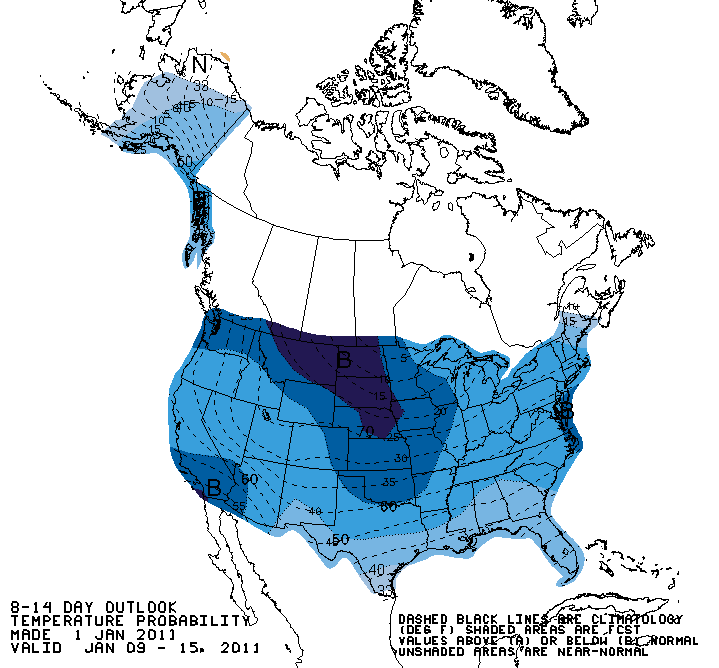
Looks like the Climate Prediction Center wants it to be cold. Here is the 6-10 and the 8-14 day outlooks.


The record books are closed for 2010. There were a few notable weather events for Kokomo, Howard & surrounding counties. Let's recap a few...


