An amazing outbreak of tornadoes.

Yesterday was pretty much as bust for our area. The conditions were ripe for severe weather but then something finally materialized late, convective conditions were waning and as fast as something popped, it faded away.
The south has been pretty active and today looks no different for them. At least things are moving east and will hopefully exit the region by tomorrow.
Our day will feature another round of rain later with limited chances of severe weather. Probably a lengthy window of clearing (sun) might change that but at this time is not expected. Some embedded storms but no outbreak of sorts. Very low tornado threat for Kokomo.
The good news is we are going to have back to back great weather days on Friday and Saturday. While some storm chance move in Saturday night, the day will be sunny and in the 70's. Get out and enjoy.
More rain is forecast. Still another 1-2 inches before we get to a dry day on Thursday. Today's rain will be limited with mostly pop up thunderstorms. These will be numerous but scattered along left over boundaries from the overnight storms.
Today will be a lot of watching for a combination of sun/heating and instability to see if we can get anything started.
We should dodge the severe weather today but will still see the heavy rain in excess if an inch tonight. Pretty quiet otherwise.
Rain will overtake the region tonight and bring significant rainfall amounts. One to three inches by Tuesday evening will bring a flash flood threat for Kokomo. I mowed yesterday and the ground was saturated before the Saturday night rains. Rain will continue to through mid week and more rain is forecast for the next two weeks.
Severe weather is also on tap through Wednesday. The only good news is we are not in the bullseye but are under a significant threat each day. Be prepared each day for severe weather. I will be nowcasting each day with updated forecasts and the day unfolds.
Take a moment and look back at last week where we had 26 tornadoes. Quite amazing when you think about. Check out Ryan's blog where he outlines all 26 of them.
http://indianadoes.blogspot.com/2011/04/26-tornadoes-confirmed-in-tuesday.html
We will be seeing a lot more of each other this week. I look forward to keeping you informed.
It has been a busy week and we got rather luck on Friday to just see rain and not any of the severe weather. Some significant damage in the St. Louis metro area and at Lambert Field. Amazing watching the reports last evening as they trickled out.
We will again see more chances for severe weather starting as early as tomorrow and continuing on through the middle of the week. Rain will continue and I can see another 3 to 5 inches in the next couple of weeks for our area. I also am not seeing any real spring warm up. A few warmer days (like today) sprinkled in through the same two week period but no sustained signs of spring.
I am going to take the day off from forecasting and weather and will be back tomorrow. Enjoy the weather if you can and take care.
I have a lot of bad news with the forecast.
We already have too much rain and we are going to get more. Another 2 to 4 inches is likely over the next week. Probably more but it is difficult to pinpoint the localized amounts.


There were six confirmed tornadoes nearby and one by the Ohio River. Two were in Cass and two in Grant Counties plus one in Boone and Tippecanoe Counties.
Here are a few rather poor lightning photos I took with my cell phone last evening.


Sounds crazy but we really did get lucky yesterday. The first round of severe weather never materialized as the warm front made slow progression northward. While we were primed to go, the fuse never got lit. There was evidence on how juiced the atmosphere was as the squall line rolled through.
If you were watching radar, the bow echo was back in Tippecanoe and Montgomery Counties but a cell ahead of the line in Clinton County went from nothing to huge in just a few minutes. It cut across Howard County going through Galveston and into Miami County.
I wonder if the 20 damaged cars at the Miami County Correctional Facility were the result of that isolated cell. It produced some very dramatic cloud to ground lightning which I witnessed.
We did miss out on some tornadoes unlike Illinois and even Ohio. I think the SREF which had shown strong indication for tornadoes was generally spot on.


Widespread wind damage with storm system. Some tornadoes and hail has also been reported. Watch the radar live. Have your weather radio on! Be ready!

The few boomers we had around lunch are nothing compared to later. The clearing to our west will grow and move over central Illinois & Indiana. Add in an advancing warm front and you will have trouble...

Today is already starting off wet and in some places, rocking. Thunderstorms are in progress in MO & IL and overnight there were a couple of tornado warnings in southwestern Indiana. Things should be quiet through lunch.
Overall the forecast has not changed so look for more activity later this afternoon....

There is a lot of talk about Tuesday and severe weather across the region. One thing absent from the conversation is the work bust. I have not heard anyone talk about a bust. While that is no guarantee of severe weather, it does give all forecasters more confidence.
So how will this play out?
First, this system and the system to follow at the end of the week will deliver a good soaking. Rain totals from 2 to 4 inches seems with isolated higher amounts seem quite reasonable. The ground is already saturated and new rain will case minor flooding and standing water. Farmers will not be having an early planting season.
Severe weather will be in two main phases on Tuesday. A warm front will move north across the state. This should provide the trigger for the first round of initiation for severe weather. The question is how strong is the cap. While better tornado parameters are south/southwest of here, they have a stronger cap. We have less inhibition so we might be more favorable.
The first severe will likely feature more isolated supercells with strong potential to produce tornadoes. These should pop first to our west in Illinois so there will be some warning. Anytime after 3 or 4 PM should be watched carefully.
The second round will a west to east squall line with embedded supercells. While straight line winds will cause widespread concern, nocturnal tornadoes after midnight will be a significant concern.
Both waves will feature large damaging hail, lightning and as highlighted before, rain.
The threat is very real and hopefully there was a bit of a wake up call this past weekend with 240 tornadoes across the south with 44 deaths. Mother nature has several rounds of serious business for us the next two weeks.
I cannot stress enough the importance of a weather radio. Supplement that with with text alerts to your cell phone using a service such as Cell Warn or Weather USA which are free or my personal favorite of Storm Now which is $2 per month.
I will do updates tomorrow as needed and plan to have a careful watch on the system and evolution. As always, my forecast will be mainly for Kokomo and Howard County.


Tuesday both daytime and evening should have a severe weather threat over all of Indiana. The evening and overnight threat looks especially serious. Tornadoes are very likely! Updates later...

Everything necessary to product a significant outbreak of severe weather including tornadoes is coming together for a Tuesday into Wednesday event. The show will start back in Missouri and if the current timing is correct, be a threat for our area in the evening into the overnight.
The SPC is already highlighting this area and I could very well see a moderate day two risk issued for our area and to our southwest.
I shouldn't have to tell you to importance of having a NOAA weather radio and a plan for your safety. Even with long lead times and advanced radar and a network of spotters/chasers, around 40 people have been confirmed dead in the most recent Thursday-Saturday outbreak.
This year mother nature means business.
Additional forecasts leading up to the event will follow.
It has been a busy week for me and I have not posted much even on Facebook or Twitter. That isn't to say I have not been following the weather. A significant outbreak started Thursday in the plain states and moved to the east coast producing more than 200 tornadoes and sadly 20 deaths. This outbreak rivals many of the big ones we all know.


Straight line wind and hail with a few embedded tornadoes will be the overnight threat. While conditions will be favorable for tornadoes this afternoon and early evening, there will not be any trigger mechanism unlike first thought. All the action will be midnight or later with the main line moving through just ahead of sunrise.
You can see the RUC has the line back in Illinois at 9 PM and the WRF has it just passed at 8 AM.


The severe weather threat for Kokomo will again be nocturnal. While Sunday will be very warm, the ingredients to produce severe weather will likely not come together until well after midnight. By then the tornado threat will be lower as a squall line moves across the state ahead of the cold front. Best timing would be 3 to 5 AM.
It is important to make sure your weather radio is working at all times but especially for the overnight events. I highlighted this a few days ago on the Facebook page for Kokomo-Weather but want to let you know the NWS transmitter which serves Howard County has been problematic recently. It normally transmits with 1000 watts of power. However various issues has cause it to fail over to a low power option with the 100 watts. Weather radios not receiving a good signal will not trigger from the alert tones. I urge you to check the location of your weather radio and position it for the best reception possible.
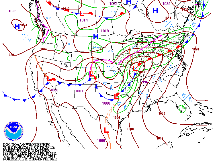
Here are a couple of maps showing the Monday squall line.


Unlike last week, the severe weather should arrive much sooner even with things slowing down. With the slower progression, we'll miss the better daytime heating but dynamics and instability will make up for it.
I'm out of town today but will be back on Saturday with the details.
The weekend continues to look potent for severe weather. Possibly will see our first high risk of 2011.

The office in Indianapolis had this to say...

Yesterday was a record setting day for severe weather. Not in the number of tornadoes which jut numbered 20 but in the number of severe reports. To be exact, there were 1080 of them. Mainly damaging winds associated with a squall line. More than 1400 reports for the two days. Rather amazing. Just imagine had there be a little bit of spin to the atmosphere. Likely would have been another super outbreak.


I am not a fan of 5 AM thunderstorm warnings. It is just too early. This morning saw the remnant convection from the system in Iowa, Missouri, & Illinois move through. No tornadoes were reported with the system. Today has seen more than a dozen and the action continues. It is a big system.

Timing of the severe weather moving east should produce a nocturnal threat for our area. Arriving after the dinner hour today and lasting through tomorrow mid day. The speed of the system should get things through here tomorrow without much time for daytime heating available to destabilize the atmosphere.
Illinois will be under the gun starting late afternoon through the night too.

Widespread severe weather is likely for Sunday and Monday. This event will sweep across Texas to Iowa and points eastward. Sunday evening will see a battle between moderate tornado parameters verses a cap. If the cap can be overcome, central MO to central/northern IL will could see numerous tornadoes late afternoon into the evening. This system will lose some punch as it moves east towards Indiana but will regain some strength Monday mid day to late afternoon.


